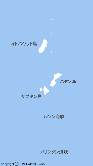
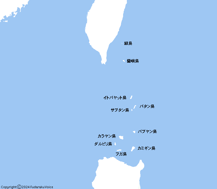
Babuyan&BatanesIslands.gif
| 第1版 Size:8KB width:751px height:654px Mime Type :gif 2024年6月2日 |
 |
© Fudaraku Voice |
|
| バブヤン諸島
wiki / Japanese invasion of Batan Island
- Wiki / フィリピンの歴史
-wiki / |
|
フィリピンと日本の歴史
- セブ日本人会 / 東南アジアのイスラム
/
クラーク空軍基地跡とスービック海軍基地跡
/ |
| |
| |
| |
| |
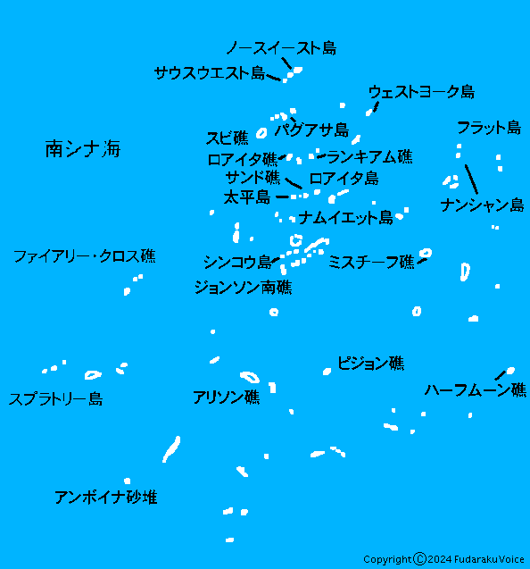
| スプラトリー諸島 (南沙諸島/Spratly Islands) |
| ファイル: スプラトリー諸島 地図 Spratly_Islands_Map.gif |
| 第2版 Size:8KB width:594px height:837px Mime Type :gif 2024年9月21日 |
| 第1版 Size:8KB width:594px height:837px Mime Type :gif 2024年9月17日 |
|
© Fudaraku Voice |
|
| 南沙諸島
-wiki /
南沙群岛
-zh.wiki / 南シナ海情勢 (中国による地形埋立・関係国の動向)
-防衛省
|
| China Tracker
| Asia Maritime Transparency Initiative / China's Activities in the South China Sea
【pdf】防衛省 |
| Spratly Island
| Asia Maritime Transparency Initiative / China says US warship's Spratly islands passage 'illegal'
- BBC News |
| The Spratly Islands | Turf Wars: A Guide to East Asia’s Troubled Waters
| TIME.com / |
| Pentagon Map Shows Chinese Outposts in South China Sea Spratly Islands
- Business Insider |
| China and Philippines Spar Over Grounded Ship in Spratly Islands
- FMSOFMSO |
| The Philippines accuses China’s shadowy maritime militia of destroying coral reefs in South China Sea
| CNN / |
| What are rival claimants building on islands and reefs in the South China Sea?
| South China Morning Post / |
| What China Has Been Building in the South China Sea
- The New York Times / |
| Great Wall of Sand
- Wiki /
南沙諸島海域における中華人民共和国の人工島建設
- Wiki / |
| Why is Vietnam rapidly building on South China Sea reefs? | Chatham House
– International Affairs Think Tank / |
| 東・南シナ海、対立の構図 6つのポイントで解読:日本経済新聞 / |
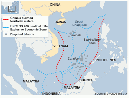
| 中国によって埋め立てられた、または構造物が築かれたサンゴ礁 |
| スビ礁 (Subi Reef)、ガベン礁 (Gaven Reefs )、ファイアリー・クロス礁 (Fiery Cross) 、クアテロン礁 (Cuarteron )、 |
| ジョンソン南礁 (Jhonson South)、ケナン礁 (Mckennan Reef )、ミスチーフ礁 (Mischief Reef ) |
| |
| 参考資料 SOURCE : UNCLOS and CIA |
| |
|
赤色線、中国が主張する領海 青色線、UNCLOS(海洋法に関する国際連合条約)が規定する沿岸各国の排他的経済水域 |
| 海洋法に関する国際連合条約-wiki / |
| |
| |
| |
| |
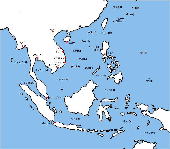
| ファイル: 南シナ海周辺地図 minamisinakai.gif |
| 第1版 Size:20KB width:703px height:616px Mime Type :gif 2012年1月28日 |
|
© Fudaraku Voice |
 | 画面をクリックすると拡大できます |
|
| |
| |
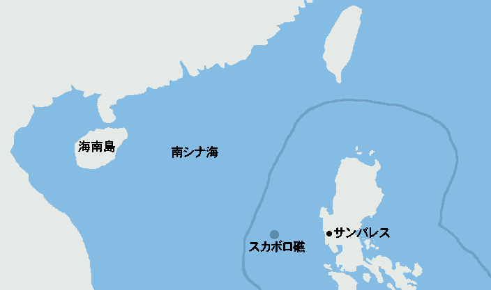
| ファイル: スカボロ礁 地図 ScarboroughShoal.gif |
| 第1版 Size:6KB width:704px height:417px Mime Type :gif 2024年12月7日 |
 |
| © Fudaraku Voice |
|
| 青いラインはフィリピンのEEZ。スカボロ礁はルソン島サンバレス州から230km
海南島から874km。フィリピンのEEZ内にある。 |
|
海南島には中国最大の三亜海軍基地がある。サンバレス州内にはかつて米軍のスービック海軍基地 があった。冷戦の終結、 |
| ピナト ゥボ火山の大噴火、フィリピン国民の悲願であった撤退要求でパンパンガ州のクラーク空軍基地とともに返還された。 |
| 米軍基地のあることで、騒音、航空機の墜落、部品の落下、米兵による凶悪犯罪、基地周辺の治安の悪化。そして何よりフィリピンは |
| かつてアメリカの植民地であり米比戦争の悪夢からも米軍撤退、基地返還はフィリピン国民の悲願であった。 |
| しかし、基地返還によるパワーバランスの変化に乗じて中国の魔手が一挙に伸びた。
このため、2023年にはアメリカ軍が再び基地の |
| 使用権を獲得し た。両基地は1991年11月26日に返還された。スカボロ礁は 2012年から中華人民共和国が実効支配している。 |
| 米比戦争
-wiki /
フィリピンの歴史_(1898年-1946年)-wiki / スカボロー礁
-wiki / |
| 第3節「フィリピンの植民地支配とマッカーサー一家」侵略国家アメリカの全貌
|國民會館 /
|
| 海南島、三亜の海軍基地を見る /
クラーク空軍基地跡とスービック海軍基地跡 / |
| |
| |
